![]() This section is valid for the following flavors: Geospatial Portal, GeoMedia WebMap Advantage, GeoMedia WebMap Professional, GeoMedia WebMap Essentials; ERDAS Apollo Advantage, ERDAS Apollo Professional.
This section is valid for the following flavors: Geospatial Portal, GeoMedia WebMap Advantage, GeoMedia WebMap Professional, GeoMedia WebMap Essentials; ERDAS Apollo Advantage, ERDAS Apollo Professional.
![]() This feature is available with standard layout only.
This feature is available with standard layout only.
Tools for selecting objects displayed on the map are grouped on the Selection tab. You can select objects by clicking on a selected object or by drawing different types of geometries.
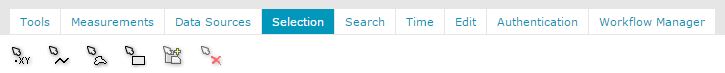
The following functionalities used for selecting objects are available in Geospatial Portal:
Icon |
Name |
Description |
|---|---|---|
|
Select features by point |
Selects all locatable objects in a designated point. |
|
Select features by polyline |
Selects all locatable objects that intersect with drawn geometry. |
|
Select features by polygon |
Selects all locatable objects within the drawn geometry and intersecting with it. |
|
Select features by rectangle |
Selects all locatable objects within the drawn rectangle geometry and intersecting with it. |
|
Add selected features to clipboard |
Adds the selected features to the clipboard. |
|
Clear selection |
Removes all selections from the map. |
In order to add another features to selection press CTRL or SHIFT key and use any of selection tool. To remove one or more features from selection press right ALT key and use any of selection tool available in Selection toolbar.
Objects on the map can also be selected by single clicking on the desired object when the mouse cursor is in the arrow state. Selected objects can be added to the clipboard to further work with the data.
![]()